October 3, 2022
|
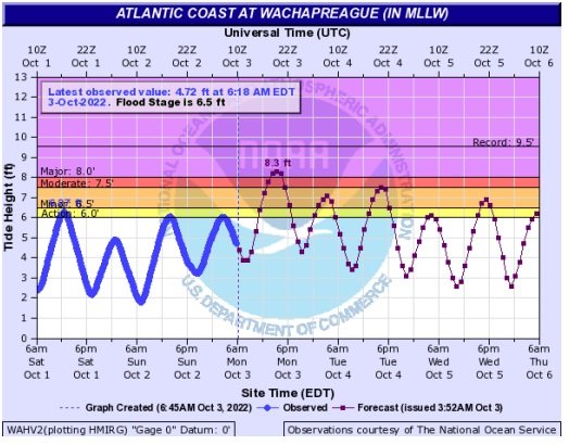
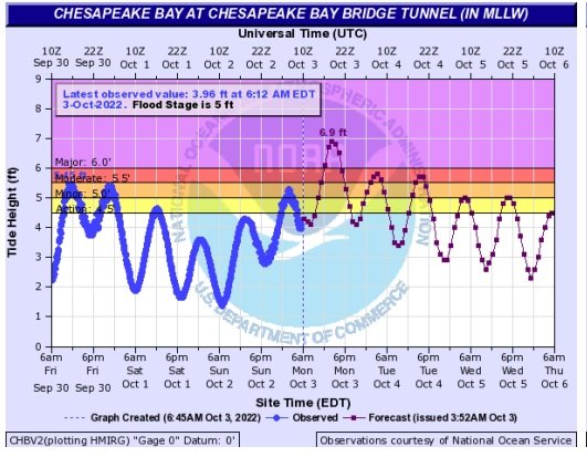
A low pressure system that is expected to stall off of the coast through Tuesday should produce much higher tides than normal on both the bay and seasides of the Eastern Shore through Tuesday. There are beach hazard and high surf warnings as well as a coastal flood warning posted through the high tide cycle Tuesday night. There will also be gusty winds on Monday and Tuesday with sustained winds in the 20 to 30 mph. range with gusts to 40 mph inland and 50 mph at the ocean beaches. An additional 2 to 3 inches of rain is expected during the period as well. Residents in low lying areas and whose roads are covered during tidal flooding cycles should prepare for two days of flooding at high tide.
Residents of Bullbegger, Saxis, Sanford, Guilford, Clam, Deep Creek, Chessaconessex, the East Point, Cashville area, Tangier Island, Harborton, Hacks Neck, Cedar View, Bayford Cape Charles and other creekside communities on the bayside should be aware that roads may become impassable during high tide cycles through Tuesday. The bayside high tides will be in the are of 6 to 6:30 a.m. on the northern bayside creeks to around 5:30 a.m. on the central bayside creeks. to. about 3:30 a.m. or 4 p.m. in the Cape Charles area on Monday. You can add 30 minutes for the afternoon tide numbers.
On the seaside residents of Oyster, Redbank, Willis Wharf, the Daugherty area, Parkers Creek area, Gargatha neck, Wisharts Point, Chincoteague, Captain’s Cove and Greenbackville could experience flooded roads limiting access during times of high tides. On the seaside, high tides will occur on or around 3:30 p.m. on Monday.
For Monday and Tuesday residents of these areas and other low lying communities should plan their comings and goings around the high tide cycles.

The highest tides are expected Monday afternoon.

A Beach Hazards Statement, Coastal Flood Warning and High Surf Advisory are all in effect through Tuesday.
For the Coastal Flood Warning, two to three feet of inundation above ground level expected in low-lying areas near shorelines and tidal waterways. For the High Surf Advisory, large breaking waves of 8 to 12 feet expected in the surf zone. For the Beach Hazards Statement, a high risk for rip currents.
For the Coastal Flood Warning, from midnight tonight to 6 PM EDT Tuesday. For the High Surf Advisory, from midnight tonight to 6 AM EDT Tuesday. For the Beach Hazards Statement, through Monday evening.

Severe flooding will cause extensive inundation and flooding of numerous roads and buildings resulting in a significant threat to property and life. Water will be 2 to 3 feet or more above ground level in some areas. Severe flooding will extend inland from the waterfront and shoreline flooding homes, businesses and isolating some neighborhoods. Numerous roads will be impassable under several feet of water and cars submerged. Some areas may need to be evacuated.
Take the necessary actions to protect flood-prone property. If travel is required, do not drive around barricades or through water of unknown depth. Remain out of the water to avoid hazardous swimming conditions.
Listen Live!
Local Weather
April 26, 2024, 11:28 am
Clear sky
57°F
57°F
16 mph
Apparent: 56°F
Pressure: 1031 mb
Humidity: 68%
Winds: 16 mph ENE
Windgusts: 20 mph
UV-Index: 4.59
Sunrise: 6:12 am
Sunset: 7:48 pm
Visit our sponsors
FOLLOW US
OUR ADVERTISERS


Member of the